Heads on a swivel you folks on Eastern Seaboard. Flo's coming.

greybeard

Herd Master
Joined
Oct 23, 2011
Messages
5,940
Reaction score
10,803
Points
553
Location
East Texas
Just when you think it can't get any crazier, some model runs start showing a building high pressure ridge stopping all forward progress just off the NC coast, then a slow southward track with actual landfall down near Georgia. I thought the models were supposed to converge the closer you get to landfall, not diverge.:he
No..different models are looking at different aspects. The consensus part comes by looking at the ensemble map. Even with it tho, the steering currents being expected to collapse about the same time Florence hits land throws a big ? mark into the picture.

By the usual standards, Florence is just average size. From today's discussion at 8:45EDT:

"Florence’s top sustained winds were raised to 140 mph by the National Hurricane Center at 5 pm Tuesday. Sustained hurricane-force winds now extend up to 60 miles out from Florence’s center, and tropical-storm-force winds extend out 175 miles. These numbers may grow even larger as Florence matures and expands. At its current size, Florence rates as an average-sized hurricane."


sizedata.jpg
Florence's size is indicated by the heavy blue line... between the dotted lines is "average" (actually, Flo is closer the lower average than a higher average.

When Ike was a Cat 4 hurricane, it had hurricane force winds (minimum of 75 mph) extending 120 miles from the eye and tropical storm winds (39mph minimum) extended 175 miles from the center of the storm.
Florence has:
Florence’s top sustained winds were raised to 140 mph by the National Hurricane Center at 5 pm Tuesday. Sustained hurricane-force winds 75mph minimum) now extend up to 60 miles out from Florence’s center, with tropical storm rated winds reaching nearly 175 miles from the eye toward the NW quadrant


This may change of course once the eye wall replacement is 100% coalesced and the eye itself contracts back to a more efficient size (the eye right now is about 30 miles across, but only because the original eyewall collapsed and was replaced by a new eyewall further out)

It definitely could stall, whether it happens just offshore or once it makes landfall is the big question and concern. Early Friday onward is going to be a puzzle..

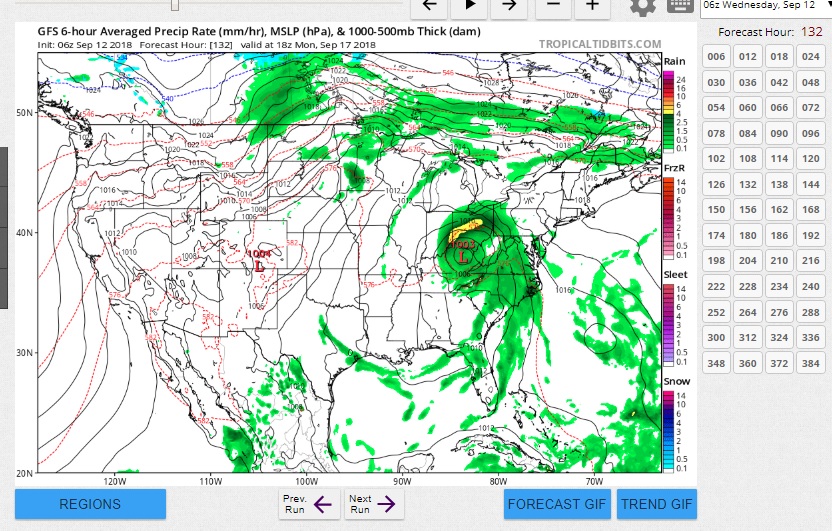
As Florence nears the coast on Thursday night, wind shear may increase to a moderate 10 – 20 knots, and the shallower waters near the coast will provide less oceanic fuel. Florence will most likely be a Category 3 near landfall—assuming it crosses the coast, that is. The steering currents driving Florence toward the East Coast will collapse on Friday, and models now agree the storm is likely to stall somewhere within 100 miles on either side of the coast, perhaps for one or two days.

The 12Z Tuesday run of the European model introduced a new and very distressing possibility: Florence stalling just offshore of North Carolina near Wilmington for roughly a day, then moving southwestward along and just off the South Carolina coast on Saturday, and finally making landfall close to Savannah, Georgia, on Sunday—all while still a hurricane. This outlandish-seeming prospect gained support from the 18Z run of the GFS model. It painted a very similar picture, with a landfall a bit farther north, near Charleston, on Sunday. The 18Z track from the experimental GFS FV3 model is very similar to the GFS track.
 
Last edited:

farmerjan

Herd Master
Joined
Aug 16, 2016
Messages
10,332
Reaction score
39,402
Points
748
Location
Shenandoah Valley Virginia
DC has been declared ....something... not a disaster area since it hasn't been hit yet.... but eligible for disaster relief. All National Guard have been mobilized in VA now, so they will be able to move to where ever they are needed at a moments notice. Camp Lejune has been evacuated. All coastal areas are under evacuation orders. Hampton Roads & surrounding areas are MANDATRY evacuation. They say it is moving a little slower and now we may not get hit til later on Friday rather than Thurs night/Fri morn. We don't need the rain, so would be glad to send it somewhere to anyone who needs it......Please put in your request and we'll see if we can send it your way..

My son works for VDOT. He said that they are just waiting to see what it does as he often has gotten sent to other areas to help. We got some cattle moved around and I have extra feed and stuff at the barn where I keep my nurse cows. Have to work Wed aft then will do last minute stuff on Thursday. Just started fall calving, but at least it is not cold and they are all experienced cows and not near any flood prone areas so hope they take care of the babies, or cross their legs and hold off. Usually the change in atmospheric pressure will cause them to calve though....
We were going to ship a load of calves on Friday.... not gonna happen this week. Had a BIG poultry swap (twice a year) to go to Saturday... I hope they cancel it and try to reschedule. It is closer to Richmond and closer to the coast so more rain and wind.... I won't go in that terrible weather.

OH WELL, it is hurricane season.....
 

Bunnylady

Herd Master
Joined
Nov 27, 2009
Messages
2,431
Reaction score
3,058
Points
353
Location
Wilmington, NC
Is that like fire season, only different? It is funny what people learn to expect based on where they live.

Oh, we have a "fire season" too; it occurs during the springtime dry spell. Even a lot of the folks who live here don't realize it, but large swathes of the southern forests are fire-dominated ecosystems. Managing woodlands here may involve "controlled burns" to limit the buildup of combustible debris (like downed trees from hurricanes). Fortunately, most wild fires in the southeast aren't big enough to make the news, and structures threatened or lost are usually limited to the property of a person who got careless when burning yard debris.

But yes, there is a large part of the year when we keep an eye on the tropics, knowing that the warm water may generate potentially killer storms. Hurricane season is understood to run from June through November, but we have seen tropical cyclones develop outside of that time period, both earlier and later in the year.
 

farmerjan

Herd Master
Joined
Aug 16, 2016
Messages
10,332
Reaction score
39,402
Points
748
Location
Shenandoah Valley Virginia
Declared DC a state of emergency.... Yep it's really a disaster at it's best. At it's worst???????
Storm looks to be trending more to the south and west now, looks like the Carolinas are going to take a more direct hit at landfall... and heading across into Ga?????
 

greybeard

Herd Master
Joined
Oct 23, 2011
Messages
5,940
Reaction score
10,803
Points
553
Location
East Texas
Yes, into Northern Ga, but depends on steering currents in the next 24 hours.
Pretty good news for NC and Va, not so much for SC, Ga, Tenn, and Ky.
A good model view at the following link. Let the page load, and each of the little numbered squares on the upper right turn white.
Click on each of the squares (one at a time) to see where the storm will be at that forecast hour, about where the most severe wind and rain will be located and precipitation per hour..
https://www.tropicaltidbits.com/analysis/models/
For instance, as of this morning, the current modeling for next Monday Sept 17 shows it to be visiting Ky, but clicking on the numbered boxes one size smaller, you can see it's path thru the very Northern part of Ga, tho it doesn't look like the center will be any farther south than SC.
 

OneFineAcre

Herd Master
Joined
Dec 28, 2012
Messages
9,139
Reaction score
10,265
Points
633
Location
Zebulon, NC
I saw the new track this morning, it's a relief for us. We are as ready as we can be.

Sorry for the people who will be in it's new path.
 
Last edited:

Latestarter

Novice; "Practicing" Animal Husbandry
Golden Herd Member
Joined
Dec 31, 2014
Messages
11,384
Reaction score
17,481
Points
623
Location
NE Texas
Best wishes to all you folks in and east of the Appalachians. I guess there's about zero chance of it turning away, so a lot of folks somewhere over there on the east coast and inland are gonna have to deal with it. I hope you've prepared appropriately. If I recollect, Hugo was a cat 3 that intensified to a cat 5 "overnight" right before landfall. Hoping this isn't a repeat... :fl
 
Top