Senile Texas Aggie - comic relief for the rest of you

greybeard

Herd Master
Joined
Oct 23, 2011
Messages
5,940
Reaction score
10,803
Points
553
Location
East Texas
I would think this is the best way if your survey has GPS coordinates.
It is what most professional surveyors use today, tho it does require you have a good signal. He doesn't have to get dead nubs on...just close enough to find the marker which is almost sure to be driven to ground level or just below.
 

Senile_Texas_Aggie

Herd Master
Joined
Jun 3, 2018
Messages
1,870
Reaction score
5,465
Points
343
Location
western Arkansas
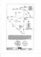
Well, folks, I finally remembered to look in all of the papers we received when we bought this place. I found an 8 1/2" by 11" copy of the survey, so I scanned it in and redacted my name, so here it is:
20181126_151500_survey.jpg

Unless I am blind or my Aggie I/Q is getting in the way, there aren't any Lat/Long readings for the markers. I don't know if the directions east and west of north and south refer to true north and true south or to magnetic north and magnetic south. We have located the two markers at the extreme southern boundary, and the metal post that is 1051.60 ft northwest of the southernmost point, but none of the other markers. It should be fun locating them as time goes by.

Senile Texas Aggie
 

Bruce

Herd Master
Joined
Feb 4, 2016
Messages
17,439
Reaction score
45,794
Points
783
Location
NW Vermont
Mine looks like that too, no lat/lon. Survey was done in 2011 when the people we bought from split the place into "buildings and 5ish acres" and the other 21ish acres. We bought both.

I guess you could get a compass and follow one of the short legs. If you don't end up in the right place, the measurements must be relative to true north and you'll have to find out what the deviation is for your area.
 

greybeard

Herd Master
Joined
Oct 23, 2011
Messages
5,940
Reaction score
10,803
Points
553
Location
East Texas
You will need the surveyor's notes to get the gps co-ordinates easily and exact. It appears when the place went up for sale, a completely new survey was not done, but instead, the surveyor just went in and confirmed a previous survey, which is why it says:
bearings.jpg

That is common practice. It's much cheaper, easier and faster to confirm old survey notes and bearings than do a full survey.

With some time to do some scaling of the picture you posted, I could probably get you pretty close in GPS.
Plug the following into a google search (maps) for your Southernmost corner: (use one or the other..not both at the same time) and then switch to whatever sat view you prefer to use.
35.082080, -93.834744
or
35°04'55.5"N 93°50'05.1"W

And as the plat's information indicates, you will be looking for 1/2" rebar with a 3/4" cap on top of it, probably very similar to what you see in the photos I posted earlier.
 
Last edited:

Senile_Texas_Aggie

Herd Master
Joined
Jun 3, 2018
Messages
1,870
Reaction score
5,465
Points
343
Location
western Arkansas
All,

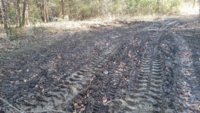
I finally remembered to take pictures of the area at the entrance to the trash dump in the woods. I stopped getting out the trash because the ground got so boggy that I was afraid of getting stuck. After waiting 2 weeks, I decided to try again. Before starting, I took pictures of the entrance before trying to get out any more trash. The first picture is looking southeast. The pond dam is to the right and the trash dump is to the left. Notice how deep the tractor ruts still are after 2 weeks:
20181128_093852.jpg

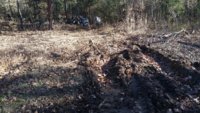
This second picture is looking northeast at the turnoff from behind the pond into the trash dump area. Notice how deep the tractor ruts are at the entrance.
20181128_093930.jpg

I started removing more trash from the area, but was only able to move about 4 grapple loads before the area got so boggy again that I had to stop before I got stuck.

What can I do to dry this area out? If I don't dry it out, I fear it will be next year before I can get finished.

Senile Texas Aggie
 

Senile_Texas_Aggie

Herd Master
Joined
Jun 3, 2018
Messages
1,870
Reaction score
5,465
Points
343
Location
western Arkansas
Right now, I am simply moving to a high dry spot in the pasture. Once I get all of the junk removed, I plan on loading it on a trailer and hauling it to a scrap metal place. Do you have any recommendations that I do it some other fashion?
 

greybeard

Herd Master
Joined
Oct 23, 2011
Messages
5,940
Reaction score
10,803
Points
553
Location
East Texas
Yep. Stop making so many trips down there to get each grapple load up to dry ground.

You are right...you will get stuck doing it like you are...I've btdt. It's like patting your foot on the cool hard dark sand of a beach..in just a few seconds water appears. Every trip you make with your tractor is forcing liquid up and turning the relatively dry top few inches into viscous crap..
Instead of making 1 round trip for every grapple load, get one of these for the back of your tractor.
They are worth their weight in preventing wear and tear and mud holes.
3pttrail.jpg


I assume you have an empty one of these:
Picture0628172243_1[16].jpg


Hook the trailer to the back of the tractor, take it down to the dump site you are cleaning up and disconnect it from the tractor. Load it with about 20 grapple loads of crap, hook back on the trailer with the tractor and instead of making 20 round trips you only make 1 round trip.
(if possible, avoid driving in the same rut twice no matter what.)
 
Last edited:
Top